Property flood information
Council has detailed flood information and free Property Flood Certificates available for the urban and southern areas of the Lismore Local Government Area (LGA).
Note: Work is underway to expand the availability of Property Flood Certificates throughout the Lismore region.
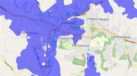
The Lismore Flood Study allows you to identify a property and access flood information to understand its potential flood risk in various flood event scenarios.
Use the Lismore Flood Study to locate your property and determine if a Property Flood Certificate is available.
For assistance navigating the Lismore Flood Study and downloading a Property Flood Certificate, access our step-by-step guide(PDF, 9MB).
What is a Property Flood Certificate?
The Property Flood Certificate contains data that will help you better understand the potential flood risk to your property. It includes information such as the natural ground level, building flood level, planning and flooding levels (including 2022 flood event), as well as definitions for commonly used flood terms.
Note: Reports are automatically generated therefore some of the information may not be correct.
How do I read my Property Flood Certificate?
The information below helps to explain some of the key features of the Property Flood Certificate:
- Building imagery: a helpful visual that includes a flood level and flood levels specific to your property, to assist you to understand the potential flooding impact to your property for selected flood event scenarios.
- Technical information: this section of the Property Flood Certificate contains detailed flood information for your property, often required for planning and development purposes.
- Mapping: provides an indication of flood depth, velocity and hazard vulnerability of a 1% AEP flood event.
- Flood definitions: useful definitions of commonly used flood-related terms.
Recipients are encouraged to obtain professional advice specific to their requirements regarding this information.
Lismore Flood Risk Management Plan
The Lismore Flood Risk Management Plan is a comprehensive strategy developed to address the risks associated with flooding in the Lismore local government area.
The plan aims to reduce the impact of flooding on the community, the economy, and the environment through a range of measures, including flood mitigation works, land use planning, emergency management, and community engagement.
The Lismore Flood Risk Management Plan aims to minimise the exposure to flood hazard in Lismore’s developed areas and ensure that new development is compatible with the flood hazard and does not create additional flooding problems. Controls that apply to new development in the flood-prone urban areas of Lismore are in Chapter 8 of the Lismore Development Control Plan.
Flood event scenarios
For details on the different flood event scenarios modelled for Lismore refer to the Lismore Flood Risk Management Study.
What is a 'design flood event'?
A benchmark major flood that forms the basis of design standards for many planning, building and development related criteria (for example, minimum habitable floor levels).
The Design Flood Event is based on a 1% Annual Exceedance Probability (AEP) which has a 1% chance of occurring in any single year. This means that if you experienced a 1% AEP flood last year, the chance of experiencing a similar flood this year is still 1%. Previously this flood event was referred to as a ‘1 in 100 Year’ flood.
What is a 'climate change flood event'?
The 1% AEP flood event in 2090 was modelled factoring in the highest climate change scenario which would see rainfall intensity increase by 19.7% and temperature increases of about 4.3°C.